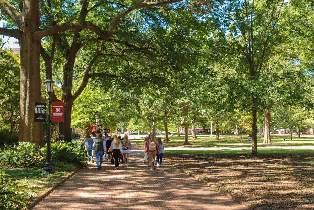
Many students' first exposure to USC's campus is through the bird's-eye view of Google Maps. When zooming in on the Horseshoe, viewers can immediately notice the web of wide brick paths all interspersed with looming trees, verdant side gardens and expansive grass fields. The image displays one of campus' greatest strengths: its walkability. Even beyond the Horseshoe, the majority of USC's campus buildings are connected by scenic and safe pathways. The classrooms of Gambrell and Close-Hipp are linked to many residence halls through the Pickens Street Bridge, a well-paved pedestrian bridge that serves as a gathering point for tablers, as well as a transportation thoroughfare. The sidewalks of Davis Field play a similar role, but the nearby Richard T. Greener statue and the Reflecting Pool provide a picturesque backdrop for traveling pedestrians. Campus pathways are shaded by trees, providing much-needed relief from Columbia's blazing summer months. Walkways are located away from roads, keeping pedestrians safe from errant drivers. Most importantly, the width of these passages allows for public events that encourage social interaction. Through USC's walkability-based design, the social life of campus can spill onto the streets.
USC's excellent pedestrian design promises a freedom of movement that is highly enticing to prospective students. Against a litany of isolated suburbs and car-centric street layouts, both commonplace in American city design, this university's campus allows students to fully exercise their newfound independence. Perhaps this is the reason why Columbia's variable off-campus walking infrastructure can be so frustrating.

There are some areas in Columbia's downtown that do have adequate accommodations for walkers. For example, the State House contains multiple walking trails that guide visitors through the grounds' landmarks. Likewise, the northern half of Main Street's footpaths are wide and well-maintained, making the street the perfect location for Columbia's famed Soda City Market. The further one goes from the city center, however, the worse this infrastructure becomes. As these sidewalks worsen in quality, pedestrians' options for walking get narrower and narrower.
In particular, the Riverfront area of downtown has few walkable pathways. Despite a variety of riverside attractions, such as the Three Rivers Greenway and Riverfront Park, walking to these places poses a great challenge. In order to get to these areas from campus, one must walk up Huger Street, a street that has thin sidewalks that are remarkably close to the road. In addition, crossing Huger is especially difficult, as the high volume of motor traffic on the road leads to long crosswalk lights. Clearly, the Riverfront was not designed with pedestrian travel in mind, and in consequence, this area is not accessible to many college students, especially those without cars.
Still, Huger's walking infrastructure is not the most egregious case of Columbia's poor support for pedestrians. Instead, this case concerns one of the most frequented areas in Columbia: Williams-Brice Stadium. For pedestrians, there are two main routes to the stadium, the first one requiring pedestrians to cross George Rogers Boulevard, a major thoroughfare for motorists attending football games. There is one crosswalk on this road between two turning lanes, meaning that one has to wait until the lane is clear before one can safely cross. Doing so is incredibly difficult during the Boulevard's high-speed, high-volume game day traffic, leading to this route being both unviable and dangerous. These difficulties have made another route more popular among students, despite its own dangers. This way takes walkers through the Greek Village and Lincoln Street before eventually turning onto Heyward Street and continuing on Dreyfuss Road, both of which have no sidewalks. The only walkable pathway for these streets is the grassy shoulder lane that is mere inches away from vehicles on the asphalt. Pedestrians take a great risk by placing themselves this close to fast-moving cars, but the lack of other walking options makes this route one of the most popular ones to the stadium.
However, Columbia’s deficiency in pedestrian-friendly infrastructure isn’t an unknown problem. WalkScore, a popular website that ranks a city’s walkability by assigning them a score (zero being the least walkable and 100 being the most), gave Columbia a 35, which classifies the city as “car-dependent.” This poor assessment illustrates a public awareness of Columbia's poor walkability, an awareness that could deter pedestrians from visiting or moving to Columbia. All in all, the town’s problems with walkable infrastructure are known by locals and non-locals alike.
These issues must be addressed, yet they must be resolved practically. Columbia does not have a large tax base, meaning that expensive city redesign projects are not feasible. Nevertheless, limitations like these shouldn’t discourage change, and Columbia’s status as a medium-sized town provides some distinct advantages for a walkable design. A key advantage Columbia has for walkability is the compactness of its downtown area, which makes it easy for walkers to travel by foot without going long distances. And while Columbia’s roads can get busy, they are not on the scale of the multi-lane monstrosities that often bisect big-city downtowns. Columbia can be a walkable town, it just needs to take small steps toward that goal.
Currently, one major step towards city walkability is in the development phase. The City of Columbia's South Main Capital District project, which recently started construction in 2023, aims to redevelop South Main Street with a focus on improving "the quality of the pedestrian environment and pedestrian safety." The main way the plan seeks to accomplish this improvement is through "the reduction of vehicular travel lanes on South Main Street," thus allowing these lanes to be reallocated for pedestrian use. Mock drawings of the plan depict sidewalks with nearly double their current width, flanked by a bike lane, a lane of planted trees and a lane for street parking. Alongside this new infrastructure, the drawings envision outdoor tables near the businesses on the sidewalk. Maybe with this new plan, Columbia's streets can showcase city culture too.
The importance of walkability extends far beyond efficient transportation. Through walking, Columbia citizens directly interact with their city. They can observe greenery and architecture firsthand, they can peer through the windows of shops and restaurants and they can admire the variety of public events and arts projects that are based downtown. Walking disrupts the hyperconvenient, destination-focused nature of car transport by exposing pedestrians to all elements of a city, one stroll at a time. In this way, a well-kept network of paths and sidewalks can inspire civic pride.
Improving Columbia's walkability would make the city more accessible for walkers, giving them the ability to engage in this civic pride. Through reasonable steps towards pedestrian-oriented urban development, this goal can be realized.


